GIS in the Field: Using LiDAR Makes Sense


Webinar Details
When:
Feb 27, 2013 2:00 pm US/Eastern
Length: 01:24 (hh:mm)
Advance Registration NOT required.
View now on-demand.
Reviewed for Continued Content Relevance: 09/2016
Presenter(s):
- Steve Nechero, Supervisory Cartographer, Branch Leader, USDA NRCS National Geospatial Management Center
- Aaron Dushku, GIS Specialist, USDA NRCS - Massachusetts
- Reed Sims, GIS Specialist, USDA NRCS - Vermont
- Steve Crabtree, GIS Specialist, USDA NRCS - Kentucky
CEU Credits/Certificate Offered:
- Certificate of Participation
- Conservation Planner (CP) - 1 hour Conservation Planning Credit
Virtual Event Format:
Group Viewing Available:
This webinar is intended for non-GIS participants who use, or might use, GIS for conservation planning and design, and natural resources analysis and applications.
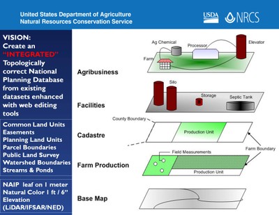
Participate in the webinar for a focus on one aspect of GIS, LiDAR data and its derivatives. The webinar will start with a basic introduction to LiDAR and continue with examples from three states. The examples illustrate (1) the improvements that LiDAR-derived data make in field operations, and (2) the three, of many, geographic products that come from LiDAR.
This webinar is sponsored by the USDA NRCS East National Technology Support Center.
Captions are provided for Internet Explorer users.